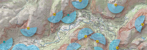
I’m taking part in the Yosemite Extreme Panoramic Imaging Project this weekend. Along with over 70 photographers and digital imaging experts we will spread out over the Yosemite Valley and will each capture gigapixel (1000 megabyte) images that will be compiled into one of the highest resolution images ever made.
The project began in summer 2007 as a discussion between xRes studio‘s Eric Hansen and Greg Stock, staff Geologist of Yosemite National Park, about constructing a high res gigapixel image of the valley walls. Such an image would become a tool for Greg’s work in researching rockfall in the park, an ongoing hazard given the large percentage of vertical faces present in the valley. Utilizing cutting edge technologies in high resolution photography as well as 3D rendering techniques, the final image will be one continuous, unwrapped panorama of all valley wall faces.
Taken from twenty different locations spread throughout the valley, we will expose over 10,000 overlapping images in unison in order to achieve a congruency of light. Later, in postproduction, the 20 image sets will be stitched and draped onto a 3D terrain model recreating all shooting positions in an extremely high resolution 3D database. From this model, a synthetic camera will create the experience as if one was flying down the center of the valley, resolving all of the gigapixel images shot into one of the largest terrestrial based images ever created. Interactive displays, large exhibition prints, visitor center installations and fine art posters will all be final tangible results of the historic project. Image completion is expected by August 2008.
Visit the Yosemite Extreme Panoramic Imaging Project site and/or Download the project proposal PDF


